What is DART+ Programme
The DART+ Programme will revolutionise travel in the Greater Dublin Area. It will see the DART network grow from its current 50km in length to over 150km. Bringing DART travel with all its benefits to new and existing communities.
It will promote multi modal transit, active transport, boost regional connectivity and make public transport the preferred option for more and more people. The DART+ Programme will deliver frequent, modern, electrified services within the Greater Dublin Area (GDA) and will improve connectivity to Regional towns and cities.
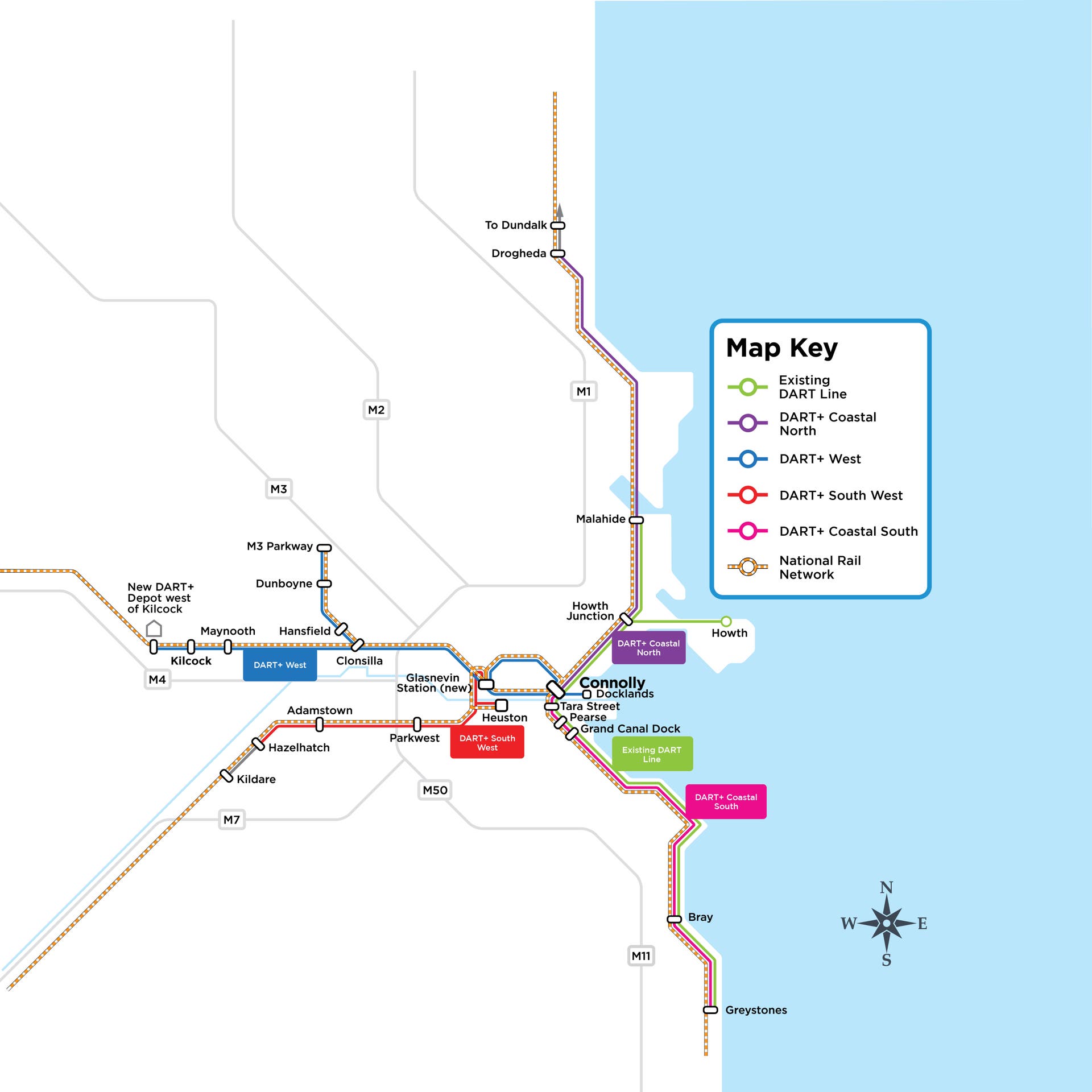
The DART+ Programme will involve rail improvements from:
- DART+ West - Maynooth and M3 Parkway to the City Centre
- DART+ South West - Hazelhatch & Celbridge to the City Centre
- DART+ Coastal North - Drogheda to the City Centre
- DART+ Coastal South - Greystones to the City Centre
- DART+ Fleet - purchase of new train fleet to increase train services.
Please accept marketing-cookies to see this content.
DART+ Programme Route Map
DART+ Programme Key Benefits
5 key reasons the DART+ Programme is needed: Over-reliance on private car, to improve land-use planning, improve integration with other modes of transport, to support economic and population growth, to achieve climate change targets.
Provides Sustainable Tranport Options
Over-reliance on private car use and increasing congestion in the Greater Dublin Area. DART trains are more sustainable and cleaner than current diesel trains.
Achieve Climate Change Targets
Will help reduce the transport sector greenhouse gas emissions which continue to rise. Supporting the Government’s Climate Action Plan.
Supporting Economic and Population Growth
Congestion in Greater Dublin Area is increasing. Cost of Time Lost in the Dublin Region is ~ €350million/annum and forecast to rise to €2,000million/annum by 2033. Sustainable public transport infrastructure (pedestrian, cycling, bus and rail) will sustain economic and population growth while reducing emissions.
Integration of Land-use & Transport Planning
Co-ordination and integration of spatial planning with rail transport. Supporting compact growth and increased densities in the Greater Dublin Area. Supports the implementation of the Project Ireland 2040 and the National Planning Framework.
Facilitates Integration with other modes of transport
Improves integration of rail services with active modes of travel (walking and cycling) Enables greater cross-modal journeys through improved integration with other modes – Bus, Luas, proposed MetroLink and Dublin Bikes.